Showing posts with label navigation. Show all posts

Article: Is the lagoon half empty or half full?

9/23/2015

gilstrap_4I think it illustrates what a navigation geek I am that of the articles I have written my favorite is my most recent in Ocean Navigator titled "Is the lagoon half empty or half full?" My article writing strategy is to write things that I wish someone had told me and if I could time travel back to my 2012 self with only one sentence from the article it would be this one:

"...with the lagoon full, the low water slack will be later than expected and the incoming tide will be weaker or possibly non existent and the high water slack will be earlier than expected and the ebbing tide will be stronger."

Yep, super geek. Direct link to the article (free) here.

Two Navionics Chart Issues We’ve Noticed

9/05/2014

First, I want to say that we are viewing Navionics charts on iNavX on our iPad. I don’t know for certain whether the issues are with Navionics charts or with the software we are using to view them.

Problem #1: In some areas that we’ve visited that have not been hydrographically surveyed Navionics has depths marked. This sounds like a great thing, right? I assume (but can’t confirm) that Navionics is using satellite imagery to mark obvious shallow areas in those non-surveyed areas. I love the idea that they are using the satellite imagery to enhance their charts – this is fantastic – but what is odd to me is that in some of those places they have assigned a depth of 5m (16 feet) to all of those shallow spots.

Take this view of SE Tahanea in the Tuamotus – one of our favorite places. You can see that all of the blue dots are marked 16 feet. Having spear fished and snorkeled a number of those blue dots close to the anchorage and having sailed very close to some of the others, I can say with absolute certainty that many of those dots are shallower than 16 feet – in fact, some are at the surface. Why assign an arbitrary and unverified depth and worse, why assign a depth that is a safe depth for most cruising boats to transit over? I hope no one is naïve enough to sail blithely over these 16 foot marks in bad visibility, but still, the charts become actively misleading when they present specific (but inaccurate) depths.

IMG_0115

Problem #2: The shallowest depth is not the depth that shows on the chart when zoomed out. The depth when zoomed out is the depth of the outer ring of a shallow spot (the deepest) rather than the inner ring (the shallowest).

Here is an example of three shallow spots from Taravai in Mangareva, Gambiers showing that at a fairly normal level of zoom, they are all marked at 32 feet.

IMG_0111

At a closer level of zoom, one shallow is now shown at 19 feet and one now at 16. The third remains at 32 feet.

IMG_0112

At an even closer level of zoom, the third shallow reveals a 26 foot depth.

IMG_0113

Obviously in this example, we could sail over all three (if we trusted the charted depths) but in others we have found shallower marks hidden.

On a positive, several countries past French Polynesia we are still finding the Navionics charts to be the most accurate. Of course, not always as this screenshot from Tonga shows us sailing right over a reef (track in yellow dashes) which was in fact to port the entire time.

Navigating and Dirtbagging

5/29/2014
In the last few months I've had two articles come out - one sailing publication and one kiteboarding. Both are available freely online. Check them out!
Ocean Navigator also featured one of our videos in their web exclusives. I've added those two articles and a previous article in a new section on Livia's List O'Links. 

Mangareva (the Gambiers): A Primer

3/07/2014

P1020579

In French Polynesia are 5 archipelagos. One archipelago, the Easternmost, is called the Gambier Islands. The only island of the Gambiers with a pass to enter for cruising boats is Mangareva. Thus, Mangareva is the name of a single atoll in the Gambiers but is synonymous in cruisers’ talk with the Gambiers.

Like many atolls, there are small islets called motus on Mangareva’s encircling reef. Mangarevas reef is mostly open to the ocean on the entire Southern side of the atoll with another large pass on the West making for little current inside of the atoll or in the main pass. Depending on the direction of the swell you may get incoming or outgoing currents in the false passes but not in the large navigable passes.

mangareva gunkholingWhat makes Mangareva unique is that inside of Mangareva encircling reef are a number of small islands – not one large island in the middle like you might find in the Society Islands (another archipelago) in French Polynesia. This means that within an 8-10 mile sail (often much shorter) you can be in a different anchorage on a different island or motu. Gunkholing paradise!

While book writers disagree on the subject, most Frenchies and Mangarevans consider Mangareva to be outside of the hurricane zone and along with the Marquesas are a common spot for European boats to cruise through the hurricane season. We are the only N American boat here this austral summer and most of the European boats are either staying here for the entire hurricane season or splitting their time between here and the Marquesas.

Most N American boats visit during the austral winter, arriving usually from the Galapagos, which is also the time of the worst weather in the Gambiers. It’s storm season here then, and the low pressure systems from the Southern Ocean whip up the seas and the winds when they pass through. Reportedly, the weather is often squally and less sunny and pleasant than the summer average. The good news is that when it is squally here, as mentioned above, there are a lot of anchorages, in close proximity, to switch between to gain protection from various wind/fetch directions.

IMG_7768The main island with “the village” is Rikitea. In Mangareva, like many remote spots in French Polynesia, there is only one village and it quickly becomes THE village to those living in, or hanging out in the atoll. We have visited many of the outer islands and many of the motus and are planning on working our way through the rest.

The only downside to Mangareva so far for us is that most of the anchorages are deep – 40 to 60 feet. While we have anchored in shallower water here, we are usually cranking like crazy people on our manual windlass to raise an enormous amount of 5/16” HT chain and our hefty Manson Supreme. We have started using a single pearl farm buoy at 2-to-1 before dropping the rest of the scope to help with the weight of the chain.

P1020698While there are pearl farm buoys to avoid when navigating, I think that this danger has been overemphasized in some of the passed-around-information. The pearl farmers aren’t interested in losing their expensive equipment (and pearls!) anymore than you are in having a line around your prop and we have found large thoroughfares left throughout the atoll for local boats (and subsequently for cruising boats).

Supply ships come regularly but not on any particular schedule and there are at least 5 small grocery stores that we know of that each offer their own selection and each have different arrangements with the supply ships. The offering is similar to the Tuamotus with perhaps even fewer vegetables on offer. Thankfully there are a lot of opportunities to exchange or be gifted fruit and vegetables.

P1020679LEAVE A CLEAN WAKE: Even more so than other areas in French Polynesia, it is important to ask permission here and tread lightly. The locals have seen a dramatic increase in boat traffic in the last 10 years and while they would like to be welcoming, the pressures we put on the local community when people arrive en masse with their bags and bags of trash from passage (for example) can be heavy. Also, while the law dictates that below the high tide line is public land in French Polynesia, there are people here who prefer if you ask permission before you anchor in front of their family motu/island/piece of land. This is not true in the village but ask around with some local cruisers before you explore the outer islands. And, as always, if you see people ashore, go and introduce yourselves – even if you have to use sign language or a phrase book.

Beautiful, Dangerous, Beautiful

3/05/2014

There are “false passes” in some atolls in which there is a spot in the encircling coral reef just low enough for snorkelers, or surfers, or even small boats to exit to the open ocean.

P1020667Last week we were anchored near a false pass (Motu Totegegie in Mangareva Atoll) and we spent some time outside the pass snorkeling and fishing in the open ocean.

Well, in the middle of a BBQ on the beach in the afternoon a group of us had the great idea to head out the pass for some fishing (trolling style) even though the tide was a little low and even though the light was already fading.

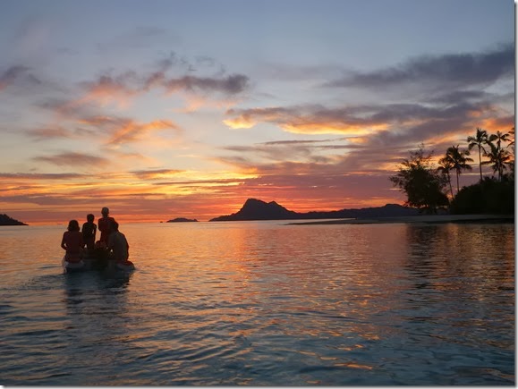
On the way back, surrounded by the light of a stunning sunset, we worked our way back, through crystal clear water that the sunlight was glancing off of, allowing occasional peeks at the what lay beneath:

P1020597

Sometimes the sunset obscured everything except what poked out of the surface:

P1020591

In each dinghy it was a team effort to spot the coral heads just below the surface before they ripped into the pontoons or broke the prop:

P1020599P1020593

Is it possible to be stressed when you are looking at this scenery? Yes…but then no…but then yes…

P1020600

Electronic charting on Estrellita: iPad, iNavX and Navionics

2/07/2014

First, if you want to know how to set up a real iPad system, and who is a fan of iNavX (with some caveats) read this post and this post by Tucker on Convivia.

We have not set up a similar system and because our iPad isn’t our only navigation system running, we are not sure yet if we will add in the expense of the iMux or similar. Maybe someday...

First, the positive: We have limited experience because our iPad is new to us, but Navionics charts have been better than our other two chart types in the 3 islands in French Polynesia we’ve visited since we picked up an iPad. If friends’ reports are true, this pattern will stay consistent as we head West next year. The general consensus is that Navionics charts win in the South Pacific.

inavx

Here is where it gets awkward. Navionics charts are expensive (on a cruising budget) UNLESS you buy them through a single vendor, for use only with iNavX, only on an iPad or iPhone. So, if you want Navionics, you essentially are strong armed into buying an iPad and installing iNavX. The cost of the difference in chart prices essentially pays for an iPad if you can believe it.

So, is being strong armed into an iPad and iNavX so bad? We love our new iPad. It can be annoying because it assumes you are mainlined to the cloud at all times and as cruisers we are definitely not. However, it is fun. It is slick. We feel like part of the techie world again. My ereader broke and although I don’t love the iPad as much for reading I’m very glad that it serves that purpose as well. We have all kinds of other apps crammed onto it that we love. Generally we’re happy to have one aboard.  The only real negative for an iPad with navigation is that because it doesn’t have an easy way to get files on and off the tablet (unless it is networked) it makes swapping files difficult and swapping tracks is a big part of the cruising community at this point. Not that file swapping is possible really with iNavX, but I get ahead of myself…

What I really don’t love is iNavX. It is a shame because it looks so pretty, and swiping your fingers around is so fun…but it cannot do so many of the things I am accustomed to being able to do, as standard, in every navigation program I’ve used. Simple, basic things really. To us it feels like an app, not a fully functional nav program. You can certainly use it to navigate around the world but it is missing the flexibility of a full nav program.

A few of the ways I find iNavX underwhelming:

  1. There isn’t a one touch MOB feature. Woah. What? A navigation program. For sailors. Without a MOB button. I’m boggled. You are supposed to tap on your position icon (hope you can tap exactly where you are in that triangle shape in an emergency) and then select “go to” from the menu in order to navigate back.
  2. The way iNavX handles tracks is terrible: cache and importing. iNavX has already decided how much space you can use on your iPad for tracks. You can’t change this. It doesn’t matter that you bought a 128GB iPad. Even though you have loads of space left on your iPad, your track cache will quickly get full. Your capacity to store tracks also clearly affects importing tracks – your own, or those given to you by another boat. Tracks are not huge files. I am accustomed to having all of my own tracks for an entire country in each of my navigation programs PLUS the tracks given to me by others. In fact, in many programs I can even color code the various tracks so I know which are mine and which are from friends (and which friends). This means, if I want to use my iPad for navigation, I have to set it up with the tracks that I want on it for every navigation rather than knowing that everything is already ready to go.
  3. The way iNavX handles tracks is terrible: naming and exporting. You cannot name a track for a given day. You cannot export a track for a given day. All you can do is export the entire track history from your iPad. Oh, and you need to do your export while online (except when exporting .kmz files if you have also downloaded the Google Earth app). We use GPS Exchange files (.gpx) because they port in and out of all of the programs we use which means we can only back up iNavX while online. That doesn’t really matter though because we don’t use our iNavX tracks because we can’t segment them with the program easily. We could download a separate program to cut and name our iNavX tracks, but why bother when it is easy to do standardly in our other nav programs.
  4. You cannot create a route in a single step.  You must first create waypoints and add them to a route in two separate steps. That’s just silly to me – clearly the most amazing advantage of tablet navigation would be the ability to tap, tap, tap your way to a route. I can click, click, click my way to a route in SAS Planet, in OpenCPN and in SailCruiser so iNavX’s route creation awkwardness felt like a step backward in software.
  5. You must use unique names for waypoints. You cannot have two waypoints called “reef” or “pearl farm” or “Pac Sea Net 1”. If you want to mark a bunch of reefs, or pearl farm buoys, or check into the Pac Sea Net on more than one passage, you have to let them have generic autogen names like WPT00023 or start making up variations. 

Caveat: We are new iNavX users and so I’m hoping to be wrong about the above. I did send iNavX an email about each of the above and they responded to our email quickly (with links to specific pages on their online help which I was able to view the next time I was online). If you know how to fix any of those 5 issues, please dish here.

Electronic charting on Estrellita: Garmin 76CX

2/05/2014

P1020419We find that in this region the Garmin BlueCharts are often offset from reality. You might be in the middle of a pass and going over land. However, despite the fact that they are usually off here, sometimes, for whatever reason, they have different info (buoys or markers or depths) than our other charts. Put simply, sometimes the Garmin chart has something on it, that exists in reality, that is missing from our other charts.

You might think that the charting flaws would be a dealbreaker but there are a number of reasons that we really love having a Garmin 76CX (actually, we have two): 1) The combination of a great internal GPS and high resolution tracks mean that we lay down very good tracks that we can then follow if we need to in an emergency, 2) They take very little power and even less power when you darken the screen, 3) They have a nice anchor alarm feature and 4) They have a convenient compass setting that we really enjoy using in the cockpit on passages to give us a running idea in the cockpit of where our windvane is taking us.

P1020420You may ask yourself – don’t you have a compass in the cockpit. YES, of course we do. But our compass doesn’t tell us whether we are right or left of our intended course, what our cross track error is, how many miles we have to go, the time (for watches) and also have charts for the entire Pacific Ocean. We frequently have our Garmin 76CX in the cockpit, plugged in 12V on passage.

It is also a handy size to put inside of our oven, or in our v-berth, or wherever we convince ourselves might be  less affected by lightning, and they are very durable in crappy weather or when dropped frequently in the cockpit (ahem).

Electronic charting on Estrellita: SAS Planet & OpenCPN

2/03/2014
sas_opencpn

This is what the split screen on our netbook looked like when we were making landfall and first anchorage at the town on Rikitea Island, in Mangareva Atoll, in the Gambier Archipelago, French Polynesia (whew! big name, small place).

SAS Planet (on the left) is a neat bit of freeware that allows you to use satellite imagery, from a variety of sources, with a GPS plugged in. It was passed to us on a hard drive but you can download it here. You accumulate a cache of satellite images while you are online. These caches can also be passed around so that the same images don’t have to be downloaded on the slow internet connections in the islands by every cruiser.

SAS Planet allows you to download satellite imagery from various sources including Google, Yahoo and Bing. Because these sources aren’t identical this is very useful. For example, if the Google image for the anchorage you want has a big cloud in the middle, you can try the Yahoo or Bing image – all from SAS Planet.

You can make tracks, and import and export tracks, routes and waypoints in the commonly used .kml/.kmz format.  I use GPSBabel to convert between formats when necessary.

There are a few things I find awkward, such as the fact that the measure tool will only give metric measurements (not nautical miles) and that you have to actively save a track before you close the program otherwise it gets dumped. Also, Google will sometimes lock you out, stopping your ability to download their imagery, if you download too much at once. Still, overall a great piece of freeware.

Having satellite imagery while offline was revolutionary for us.  If you like to pore over images to find out of the way anchorage possibilities, to imagine routes through reef laden areas that will allow you to go somewhere that other people are not going, satellite imagery in some form is the ticket. We had previously tried the Google Earth plug in for OpenCPN and, at least at that early stage of development, found it cumbersome. Take a look at the difference between a CMAP chart and SAS Planet in this close quarters reef navigation (yes, yes, we used our eyes as primary).

reefie

OpenCPN (in image above on right) in its newest iterations is a very useful piece of software. It is not as slick as our previous (purchased) navigation software (NavSim’s SailCruiser), but, well, it’s FREE. I love the flexibility and customizability of it. Importing and exporting tracks, routes and waypoints between our various programs is easy. Almost everything in the program can be customized or turned off or on. The plug in we find most useful is the GRIB visualizer. The older versions of OpenCPN worked with a Fleet Nadi plug in as well but we haven’t been able to find that plug in for the newer versions so we are currently running an older version because we download the Nadi Fleet Code regularly with our SSB.

In order to run both programs simultaneously with one USB puck GPS, we downloaded and installed Franson GPSGate. This allows us to take the single COM port created by the GPS and turn it into a bunch of virtual COM ports which can then be assigned individually to any program that wants one.

Electronic charting on Estrellita: The State of Affairs

1/31/2014

P1020417This is part of a series on the state of affairs for electronic charting on Estrellita.

Notice that I did not claim this was state of the art.

One thing I enjoyed about running the IWAC Project particularly when I was prepping, was reading about what cruisers are actually doing – not what someone says is the ideal, not what a prepper has carefully researched (and is probably the best) but what people “out there” have cobbled together and are getting along with.

In that spirit, this is the set up we currently have that allows us to get around where we currently are...and we aren’t dead yet. 

I loosely divide charting philosophies for cruisers into “gold standard” vs. “variety of options”. Of course, like any interesting dichotomy, most people think they are striking a balance between two extremes. However, since everyone’s balance varies from one side to the other, the dichotomy is still useful.

We have definitely taken the variety of options approach to navigation. This is probably not so much because of planning as it is because over time we’ve accumulated different resources and over time the options have changed. Still, although it may not have been put together with a master plan in mind, now that we have all of the options, we are glad to have them. We really like to see a few different types of charts for an area, plus satellite imagery when planning a trip. 

Fairly regularly, on a short sail, we will have 4 methods of charting running. These four methods are:

  1. SAS Planet (freeware) running on a cheap netbook with a USB puck GPS.
  2. OpenCPN (freeware) running split screen on the same cheap netbook with the same USB puck being ported out to more than one COM with the software Franson GPSGate.
  3. A Garmin 76CX running Garmin BlueCharts.
  4. An iPad with iNavx and Navionics charts using only the internal GPS.

On passage we usually have either the Garmin or the iPad running, but not both. The Garmin and the iPad are low power consumers even compared to our old netbook. When we open the netbook for other things we will usually check in with OpenCPN as well but obviously for passages we rarely use satellite imagery – that would just show us a lot of blue water and clouds.

I’ll follow this post with a bit about each of the above.

Cruising Tikehau

8/06/2013

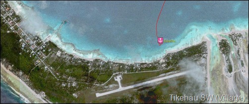
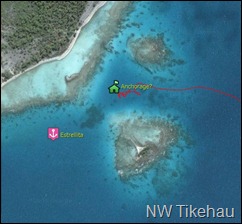
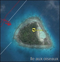
Click on any image below to be taken to Google Maps at that location.

tikehauvillage 

tikehauNWUsing the word “anchorage” in an atoll in French Polynesia is a little weird because there are miles of anchorable depths in more or less protected regions of the atoll and it is fairly rare that there is only one good spot even in the well protected region. Boats tend to congregate near villages, or near waypoints given out in guidebooks.

When you find your own little corner of paradise, away from a village and away from the guidebook waypoints, another boat will see you anchored and come over to investigate your spot. Not that I’m complaining too loudly because we’ve done that ourselves. Always wondering if the other guy found something good. We’ve become better at moving around and finding our own corners. Satellite imagery has made locating good spots a very fun game for the navigator.

tikehaubirdmotu Tikehau is an atoll in the Tuamotus that is interesting in a number of ways. Tikehau is relatively small which is usually good news for wave build up across the lagoon (i.e., fetch).

However, it is a circular atoll and we found that the fetch wrapped around and so always seemed to hit the boat just a little bit off from the direction of the wind. Because the boat was facing into the wind, the fetch hit the boat at 20-30 degrees and caused, not a rolling motion, but a short little jerking motion that drove Carol and I bonkers.

tikehauNEWe started calling it Lumpy-how and we had to get rather creative in avoiding the fetch in order to enjoy this atoll (which is beautiful, more on that later). tikehaupbrWe ended up anchoring in more unusual spots, surrounded by reefs, or behind a line of coral heads or behind an island in the middle of the lagoon. We also moved around a lot as the wind switched. it was fun to explore an atoll “fast”. We kept joking that we were cruising charter style, never spending more than a night or two at any one anchorage.

We spent a night or two anchored in front of one of the expensive honeymooner hotels and it was fun to have the same view and to be reminded of how much of a dream location we are currently cruising in.tikehaupass

You can always see where we are currently anchored by checking out our map. Switch it to satellite view if you wish to see images like these.

Maupiti and Solar Tides

6/24/2013

Did you know that some places are relatively unaffected by lunar tides but seriously affected by solar tides?

I (Livia) wrote an article that appeared in a recent issue of Ocean Navigator on the application of solar tide knowledge to navigating passes in the places like Maupiti, French Polynesia. You can read the article online here.

Thanks to Michelle on SV Cheers who first told me about the topic.

Tragedies in the South Pacific

12/15/2012

During the 2012 season we kept hearing about other boats' tragedies - each one a convincing reminder to us to be diligent and focused while cruising.

Below are four reports of vessels who went aground on reefs, reporting everything from only cosmetic damage to dismasting. We heard of at least twice as many groundings but won't mention the boat names of anyone who hasn't posted publicly about the grounding themselves.

For a few other newsworthy events this season, check out the following reports:

We don't want to be armchair sailors and judge anyone without knowing all of the details. We want to thank the people who posted about their groundings because they are important reminders and learning points for the rest of us.

On the subject, I recommend that people read Karen's letter about a vessel abandoned on the high seas (Windigo) as an educational thought exercise on our obligation as sailors if we abandon our ship. Scuttling isn't just a fun pirate word...

Rogue Waves and Determining Longitude at Sea

11/20/2012

I’ve been meaning to write about two books that I read on our crossing from Mexico to the Marquesas that I had set aside just for that passage and enjoyed a great deal. Honestly, I thought I already wrote about them but I can’t find the post in my offline writer or on the blog so apparently I didn’t. Is there a cruiser version of senioritis or can I get senioritis before 40?

Both books are non-fiction and both are the type of books that, in my opinion, if you like the idea of the book, you will like the execution. If the idea of the book sounds boring, give it a pass.

The first is a book about rogue waves by Susan Casey called “The Wave: In Pursuit of the Rogues, Freaks and Giants of the Ocean". Although perhaps a questionable choice of book to read while surrounded by hundreds of miles of ocean with no port in sight, I loved the book. I particularly enjoyed the fact that she skips back and forth between information and viewpoints from wave scientists, big wave surfers, and shipping companies and insurers.

The second book was about the discovery of longitude, or rather, the accurate measurement of longitude on land and later on sea. The book is “Longitude: The True Story of a Lone Genius Who Solved the Greatest Scientific Problem of His Time” by Sobel. It is a bit nerdy, engaging and concise and I really enjoyed it.

I’ll bet your local library has copies of both or if you are feeling flush pick up a copy for yourself when you are ordering your holiday gifts from Amazon.

How long will it take?

3/10/2011
This one is for our non-boating friends.

We are often asked “how long does it take to get from (the place we are) to (this other place)?” and we hem and haw and say “well, it depends” and they look slightly annoyed and counter “just a ballpark” as if we are being purposefully vague and we make something up to be polite.

Why can’t we give a better estimate?

Let’s take the example of sailing from Vancouver to Silva Bay and let’s stick with the round number of 20 nautical miles as the approximate distance. We had a forecast of variable 5-15 knots.  FYI: A nautical mile is slightly longer than a statutory mile and knots are nautical miles per hour. Nautical miles are cooler than statutory miles because a nautical mile is one minute of latitude and so when looking at a chart you can use latitude to reckon distances.

Now first, what if we had 5 knots of wind? If that wind is coming from in front of us at about 60 degrees to our right or 60 degrees to our left, we might be able to sail at 4 knots (5 hours travel time). If that wind is behind us directly, we might be able to sail at 2 knots (10 hours travel time).

P1010610 (960x1280)Readers will remember however, if the wind was directly ahead of us, we have to zig zag and so we might only make 1 knot toward our destination even if sailing faster through the water (20 hours).

If the wind was on the high end of the forecast and we have 15 knots of wind also at 60 degrees to one side, we might make 7 knots (3 hours of travel time) or if the wind was behind us we might make 5 knots (4 hours of travel time).
This means that in the simplest conditions we might take from 3 hours to 20 hours to make that trip.

Complications: A current against us would add time and a current with us would subtract time on either end. Waves slow us down if they are coming from ahead and speed us up if they are coming from behind. We might be the kind of boat that decides to motor if sailing less than a certain speed. As the distances get longer, the variability becomes greater. For example, a 40 mile trip in the same conditions could take 6 or 40 hours. Of course, I don’t know many people that would zig zag back and forth for 40 hours by choice. Finally, the length of the boat, the type of sails the boat has, its shape in and above the water, and the expertise of the crew all make a difference in how fast different boats go at the same wind speed.

Raymarine A50 with "Rest of World" Charts

1/21/2011
Our very old Raytheon Raynav 300 GPS is dying and we are trying to decide what route to go in replacing that functionality (main GPS, plus course-over-ground in cockpit on autopilot control head). Our autopilot is a Raymarine Smartpilot and it's nice to have the two talking to each other.

As far as I can tell we can't just buy a GPS anymore, we have to buy a chartplotter. The simplest by Raymarine is the A50. For not terribly more than the base model you can get one loaded with Navionics charts for the "Rest of the World" (interesting name for everywhere except the US, Canada and Europe, isn't it?).

However, although the regions are listed, neither Raymarine or Navionics appears interested in telling me what detail the coverage is. They won't give me a chart list, just a map with regions circled and they won't tell me the level of detail/zoom.

The only thing Raymarine would say is "Depth contours would be available out to 5m." If I'm understanding that correctly, you would have a chart with a "deep area" and then a line at the 16 foot level with depths under 16 feet listed.

For the money we are may try to interface our PC system (we have a PC with a DC-DC regulator and a USB GPS puck) to the autopilot instead but I'm posting in case anyone has more information or experience with that plotter-package? I've tried searching unsuccessfully online.

Rain hurts

12/26/2010
New realization: With winds above 30 knots, rain hurts.

We left Port Ludlow to head South in forecast winds of 10-20 knots SE increasing to 20-30 South. Actual winds by 13:00 were sustained SE winds of 25-30 true with periods of sustained true winds above 35 knots with gusts close to 40. This meant we were seeing apparent winds while beating mostly of 35. They amended the forecast while we were sailing to 25-35 knots.

Translation for non-boaters: Strong wind, and in the wrong direction.

Did I mention that all of the daylight hours right now are on an ebbing current (not good for heading South)? And that with the extreme tides and storms that the Puget Sound is a mine field of telephone pole sized logs?

We returned to Port Ludlow to mull this over.

Just gotta have more cowbell

9/16/2010
This is one of those things that I should know, but don’t. Any readers able to help?

For our non-boating friends, in Americanada when you are in “the open” and you want to enter “a harbor” (fuzzy concepts that get very confusing when you have two harbors connected by a channel) you keep the red buoys on your right side and the green buoys on your left side to avoid any crunchy bits touching your boat. This buoy coloring fact spawned the mnemonics “red right returning” and “red left leaving”. Major buoys in the ocean often also have lights that flash in certain patterns so they can be identified, loud sounds and have stuff built in so that they show up as larger-than-they-are blips on your radar screen – all so that mariners can find their way to safe harbors in the dark and in the fog.

To my question for the boaters: It seems to me like the red buoys out here on the W Coast moo and the green buoys clang like a cowbell. Is it just the case that some buoys have bells and some have horns and randomly I’ve been seeing red ones with horns and green ones with cowbells or is this a planned fact that you can use to guide yourself into the harbor in the fog?

Boatwork at anchor

7/21/2010

The first day the winds were too strong for kayaking in the Polkinghorne’s so we did some boat maintenance.


First, we took down the huge 130% (150%?) Genoa on which we had blown the sunbrella stitching on the sail over. The sunbrella stitching was the only thing holding in the leech line (bad design IMHO, the leech line could have been stitched with stitching underneath the sunbrella and thus protected from UV). We replaced the genoa with our working jib. It has a much, much nicer shape when reefed because of its smaller size and we are definitely in reefing strength winds lately.


Before we put up the jib I wanted to do a few small improvements that came up in Carol Hasse’s sail repair course when we examined this sail as a class. Primarily, I wanted to put leather chafe gear on the head and the tack which would protect simultaneously from chafing on the metal furling and halyard attachment points hand also protect these two pieces of webbing from UV. Done. I also hand sewed a few places where the sunbrella stitching had rotted off (on this sail as well - *sigh* UV thread anyone?). While doing so I saw that the areas that had ripped were between areas that had already been repaired. At least the previous repairs were in great shape. I probably restitched 10% of the length of the sail, anywhere there was stitching coming loose. Hopefully the sunbrella will stay put for a while.


Resized IMG_4568


Carol was a boat working machine and finished the SSB backstay antenna by terminating the wire inside the hull to the tuner with a ring attachment and he also ran the foil from the tuner amidships.


Then he removed our broken hinge from the aft starboard lazarette and attempted to remove the seized pin. However, during this attempt the hinge made a successful escape from the Estrellita foredeck prison and is now free to roam the bottom of the E bay at the Polkinghornes. Any Pretorien owners have an extra upper hinge for that lazarette? I’ll post on the owners’ forum later.


The hinge still imprisoned:

IMG_4570


Finally, he wired the AIS for power and the antenna splitter for it. So we now have AIS reception (non-boaters, this is so we can see large ships and know which direction and speed they are heading so we avoid being crunched). Here you can see our navigation program (NavSim’s SailCruiser), we are the pink dot with the yellow track (we are tacking upwind to Blunden Harbor) and I’ve clicked on a boat so you can see what information that it is broadcasting that we can now see. The little brown circles with M’s are markers we made when we dropped anchor so we could see where we were compared to where our anchor touched ground. The yellow arrow just below the box is the current at the time I took the screen shot.


ais


All of that he did while I was still stitching a single sail. AND, after that we connected via SSB to email and downloaded some practice weather files, checked in with the Great Northern Boater Net, and listened to the Pacific Seafarers net.


At Lewis Cove I cranked Carol half way up the mast and he installed our starboard spreader halyard. Non-boaters, this rope allows us to fly flags on the starboard side of the boat. We fly our Canadian flag from the back but we have smaller flags that get flown on the starboard side like courtesy flags for countries we are visiting (small US flag right now) and also any club flags (aka burgees) for clubs we belong to. We also have some fun flags like a pirate and martini flag (THANKS SARAH & CRAIG) and a huge Wauquiez flag we picked up at a rendezvous.


This was supposed to be our relaxing few days of becoming more cruiserly, remember?


We’ll get the hang of this retired thing eventually. – Livia

50 47.68 N; 126 55.38 W

LIQUID MOTIVATION

Click on the dollar and buy Livia and Carol a cold frosty one:

DON'T MISS A POST

Enter your email address:

Delivered by FeedBurner

INSTAGRAM

RANDOM POSTS